Going through the mechanics for Journeys in Dragonbane, I came upon this rule in the section on resting:
“A shift rest lasts one full shift of time and can only take place in a safe location where there are no enemies nearby.”
Other rules in the Journeys section indicate pretty strongly that the writer assumes anywhere that isn’t inside a dungeon to be a safe location. But personally, I wouldn’t consider pitching a tent in the goblin hills or spider woods to be “in a safe location”. Ultimately, what is safe enough to allow the PCs to rest is at the discretion of the GM.
For the Woodland Vales system, I really want to players to set up proper base camps while exploring a stretch of wilderness, where they can store their food and other supplies, as well as the heavy treasures they find under the guard of their hirelings who also take care of the pack animals. Using a more severe interpretation of what constitutes a safe place for the purposes of resting immediately makes this a much greater necessity without really touching the rest of the Dragonbane rules at all.
Similar to the havens (I think that’s the term) in The One Ring, finding the home of a friendly NPC, the shrine of a benevolent spirit, or an abandoned tower with intact walls can be a hugely beneficial discovery. A location secure enough to regain all HP and WP and remove all your conditions becomes a key resource for the ability to delve further into the unknown wilds. Without it, you can only get four Round Rests to recover 1d6 WP and four Stretch Rests to recover 1d6 WP and HP per day.
A less severe approach to this is to assign all outdoor areas a security rating of safe, wild, and dangerous. In a wild area, the Bushcraft roll to find a suitable camp site for making a Shift Rest is made normally. But in a safe area it is rolled with a boon and in a dangerous area with a bane. In a dangerous area you might still be able to find the occasional safe campsite to make a Shift Rest, but with a bane (roll twice, take the worse result) it would be quite unpredictable which nights you will be able to. Even with this house rule, any place that is reliable secure and does not require Bushcraft checks at all would still be a very valuable resource.
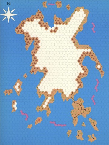
I’ve never been friends with the idea of hexcrawling. Lots of people fill the term with all kinds of different meanings as long as there is at least one hex map involved somewhere, but to me it always carries the clear meaning of being the same concept as dungeoncrawling, translated from dungeon rooms to wilderness hexes. Which means the players are going from hex to hex, color in the new hex on their map as the terrain type they discover, and ask the GM if they see anything that they can check out. Like the player map for The Isle of Dread.
Some people will say that hexcrawling is much more than that, but there’s plenty of people around who strongly assert that every single hex should have something in it to discover, so the idea is there. That just doesn’t sound very fun to me, as it easily turns into wandering around aimlessly waiting for something to happen. I also think it breaks the believability of the world as a 24 square mile area is massive and you could spend month exploring just a single 6-mile hex without ever spotting a cave, statue, or tower that is somewhere between the hills and trees. As I outlined in a previous post, I think it is much more plausible for PCs to find new sites when they either have instructions for how to reach them, or they are visible from a road or river the party is travelling on. In many ways, this is simply a pointcrawl. But there are various things about the pointcrawl map as originally proposed that I find inconvenient for how I want to run my campaigns. Where do you put boxes for new sites that are added to the world as a consequence of players tracking randomly encountered creatures to their lair or base without messing up the map? What if players decide to take shortcuts through woodlands or swamps where there are no roads or rivers to follow? These issues can be quite easily fixed without really overturning the whole system, so consider this a tweak on pointcrawl maps.
First thing is to draw the map for the area in freehand with no grid. (Even the hexmaps I posted recently started that way before I added the hex grid.) Primarily coastlines, mountains, rivers, lakes, and swamps, and such things.
Second, add the major settlements, strongholds, and ruined cities to the map.
Third, draw the roads that people build to connected these settlements.
Now that we have the main rivers and major roads, as the fourth step, add any other sites that people in the area might have discovered already and could give the players instructions on how to find them.
Fifth, add the secondary paths that connect these sites to the main roads and rivers.
Now we know all the paths through the region that parties are likely to travel on. As the sixth step, add sites that could be spotted by simply traveling on one of the primary and secondary paths.
Seventh, mark paths that connect those tertiary sites to the road and river network. Since characters can see those sites from the road, they don’t need any kind of trail to follow. Just keep it in your sight and move towards it. Depending on the granularity you want with distances, these can even be marked as being right on the trail from which they can be spotted.
Only now comes the step to add a hex grid to the whole map. This hex grid is not to divide the wilderness into segments, but simply as a visual aid to easily estimate the length of swirling paths as they meander through the environment. If you’d want to, you could just note the distances between two points next to the path of the map and remove the grid again if you’re working with a digital map. Back in the day, the 2nd edition Forgotten Realms Campaign Setting box had a hex grid printed on a sheet of clear plastic at the same scale as the maps in the box for just that purpose. I think any print shop would still be able to make such a sheet for you if you have an apprpropriately scaled file of a hex grid on a USB stick.
The advantage of making a wilderness map like this is that I can easily add more dots and more lines to the map, and since the map is based on physical geography instead of a flow-chart abstraction, I can determine the length of any new path easily by counting the number of hexes it passes through. If the players say “You know what, we get off the trail here and just keep heading straight south until we reach the river and then follow it downstream to the town”, it’s trivial to figure out the length of the path, though it would be something you’d have to purely handwave on a default pointcrawl map.
Which might of course be a complete non-issue for many people. This is simply my method that I am using to get the mix of abstraction and precision that I find ideal for my campaigns.
Encumbrance in D&D has always ranged from bad to terrible. The idea behind encumbrance is actually great. The default assumption for the first decade or so had been that the party enters a dangerous place, gets their hands on valuable stuff, and gets back out again, preferably with their loot and without anyone dying. When wandering monsters are a thing (look forward to part 3) and fighting battles is a negligible source of XP (look forward to part 4), then getting in and out quickly is of the essence. The longer it takes you, the greater is the risk of anyone dying with no benefit in trade. So as you keep delving deeper into the dark unknown, you are using up some of the tools and supplies you have brought with you, but at the same time get weighted down by the treasures you find. Which leaves you with two choices. Slow down and risk fighting more opponents and reducing your odds of being able to run away. Or reduce your weight, either by choosing to leave some of the treasure you’ve found behind, or by dropping some of the equipment that you hopefully won’t be needing on your way back to the surface. Hang on to all your potentially life saving tools and weapons as you slowly crawl back to the exit, or make a mad dash to safety? Or play it safe and leave some of your hard fought for rewards behind? This is a real question that players will have to face. There is no right answer which two out of these three you should choose and will greatly depend on the constantly changing situations. To me, this is one of the big things that make exploration adventures so exciting.
Random Encounters, XP for treasure, and Encumbrance are really a single unified system. They really only work together as a unit. When you ditch one of them, the other two stop serving any purpose as well. And I think most of the time, Encumbrance is the first one to go. Because the way D&D handles it is just so annoyingly tedious that almost everyone very quickly, if not immediately, decides to just not bother with it at all. Whether you calculate your character’s equipment load in pounds or in coins, every time you pick up an item or drop an item, you have to adjust your current encumbrance load value. And inevitably you will sometimes forget it or make mistakes, requiring to make a complete recount of all your inventory and calculate all the different weight again. Nobody thinks that’s fun. To really do that, you need to keep your inventory on spreadsheets, and playing the game with everyone having a computer open can’t be the way to go. So out the window Encumbrance goes, making the whole exploration system pointless.
But there is a solution, and it is brilliant in its simplicity. It also isn’t mine. This idea is taken pretty much straight from Papers and Pencils. I don’t really add anything significant to it, I am just aligning it with my exploration system here. What this system does is to say “calculating loads by weight doesn’t work because nobody uses it, let’s drop the idea of doing it ‘realistically’ and use a much simpler system of inventory slots”. Yes, it’s a greater degree of abstraction, but as I always keep saying all of the numbers in these mechanics are make believe anyway, and a system that people would want to use is always better than a system that always gets ignored.
The basic, and really very simple idea is that any items have a weight that is either “insignificant”, “significant”, or “especially heavy”. Insignificant weight means the item has an encumbrance value of 0, significant weight means it has an encumbrance value of 1, and especially heavy items have an encumbrance value of 2 or higher. To assign an encumbrance value to an item, my rule of thumb is round up the weight in pounds to the nearest multiple of 10, then drop the last 0. Items with a weight below 1 pound have an encumbrance value of 0.
The amount of items a character can carry is as follows:
Speed
Max. Load
Effect
Unencumbered
STR x 1
—
Encumbered
STR x 2
Speed -10
Heavily Encumbered
STR x 3
Speed -20, disadvantage to Str, Dex, and Con
And that is the entire system. But you can even simplify this even more by setting up your inventory sheet in the right way. I recommend making a dedicated inventory sheet like this, but you can try squeezing it into the inventory space on your character sheet.
There are two columns for items. One for items with significant weights that add to encumbrance, and one for items with insignificant weights that don’t. On the left side you have all the rows numbered. When you now put all your items with significant weights into the left item column, and make them take up as many lines as its the encumbrance value, you no longer have to calculate anything. Your current load value is right there to the left of the last item on your list. To make things even easier for you, you can mark the lines that match your Strength score times 10, 20, and 30. In this example, the character has a Strength score of 13, so he is unencumbered with a load up to 13, encumbered with a load up to 26, and heavily encumbered with a load up to 39. The line below 13 items is marked green here, the line below 26 items marked orange. When you add or remove items on your inventory list, you immediately see when your current encumbrance category changes. The column with the items of insignificant wight doesn’t matter, I just thought it fits conveniently in the place where it is here.
Next to the numbers, I added another column as a recently added new feature. In this column you can mark if the items are part of your Arms, Exploration Gear, or Travel Gear. If you keep them sorted like this, it becomes trivial to say “I put down the backpack with my heavy travel gear and continue forward with only my arms and my tool pouch”. Again, no new calculations are needed. In this example we immediately see that the Arms and Exploration Gear cross below the green line, but stay above the orange line. That means when I drop my backpack with my tent, food, and spare clothing, my encumbrance will be Encumbered.
I did play around a bit with an idea of keeping track of various pouches and sacks characters might be carrying, but that just ends up disrupting the neat simplicity and easy of use of this system. So again, I just said eh!, and went for the more abstract option that requires the least amount of bookkeeping and rearranging your inventory. Though I admit I still don’t have a perfect idea what to do when characters go into a dungeon with empty space in their Exploration Gear pouch that later gets filled with treasure that they pick up. Right now, this still requires you to move an item from the top of your T-items to the bottom and adding the new item as an E-item. Maybe this can be improved as well, but I think so far this is a really damn good inventory management system, far better than anything you find in almost all versions of D&D.
While working on my wilderness setting it became obvious that running it would require a solid and easy to use system for overland travel. There are tables for Travel Pace in the Player’s Handbook and additional rules in the Dungeon Master’s Guide to deal with overland travel in 5th Ed., but just like the tables and mechanics in 3rd Ed., I find them very impractical to use in actual play. If you use them rarely, it’s difficult to remember how it all works, and if you use them frequently it’s way too much calculating and eating up too much time. I plan this to be a series that will put together a complete system that is easy and fun to use and covers all the relevant aspects that are part of wilderness travel. Which is movement speeds, resoure management, encumbrance, random encounters, and weather. All of this will be based heavily on the 1981 Expert Rules by David Cook. Those are a really good start and reference point, but they can be improved and require some tweaking to work with 5th Ed.
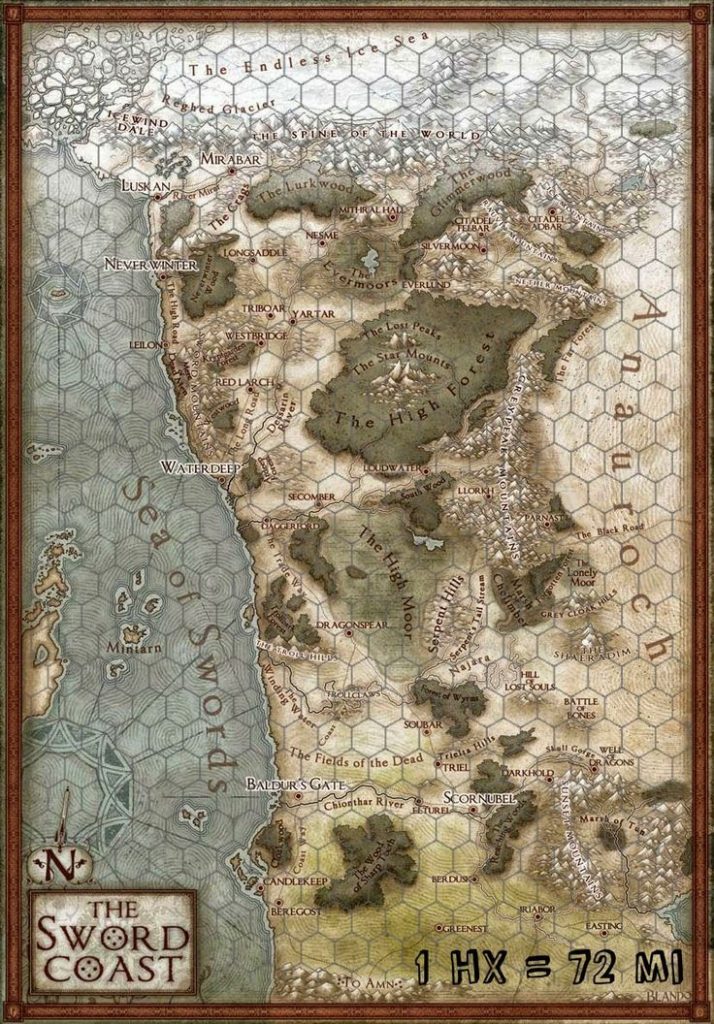
I have a long and very conflicted relationship with hex maps, which I attribute primarily for my distaste of hexcrawl campaigns and my appreciation of pointcrawls. But using hexes to measure distances and treating hexes as discrete areas are completely different things, and my dislike of the later is no reason to completely discard the former. One reason I don’t like hexmaps is the amount of time it takes me to make anything good looking. Another is the way in which it makes the players interact with the fantastic imagined world. Filling in little white hexes with as you move along really feels just plain wrong to me. But when you just want to measure distances and see whether the movement is along roads or through plains or not, then you can simply add a hex grid overlay to any existing map. In most situations, you are going to need separate maps for the players and the GM anyway. I recommend the GM-map with all the secret locations marked on it getting a hex grid overlay, while the player map does not. But ultimately, what made me decide to use hex grids for this system, was the issue of parties getting lost. This seems quite important for a system intended to be used in a giant forest without roads, and I just can’t think of any way in which this could be handled on a point map.
Using a hex grid to measure distances for a journey has been a long established tool, but neither 3rd nor 5th Ed. are designed for it. When you try to convert movement rates to hexes, you always keep ending up with the party traveling 1/2 hexes over a full day, or 3/4 hexes. Which I think defeats the entire purpose of measuring distances in hexes in the first place. So I made the decision to not attempt doing that and instead begin the entire design process by creating a system in which movement can only ever happen in full hexes and everything else will be tailored to fit on top of that.
I decided to use the Travel Pace table from the PHB as reference, which has speed always being either fast, normal, or slow, and the terrain either being regular (easy) or difficult, with difficult terrain taking double the time to cross than easy terrain. 3rd Ed. also had terrains that would take 1/4 or 3/4 normal time to cross and while that may seem more “realistic” it really makes things needlessly complicated. All of this is pure make believe anyway, somewhat inspired by reality, but completely disconnected from it. Two types of terrain is enough, and I also don’t consider it to be useful to account for the different walking speeds of smaller and larger creatures. While there are significant differences in running speed that matter in tactical combat, when travelling an entire day we can simply assume that smaller characters have the natural stamina to walk at a faster pace to keep up with the walking speed of larger characters. Stamina is also the reason why horses generally don’t travel further in a day than humans. The important difference is that a horse can carry all your heavy supplies with ease without being slowed down by them as you would. So three movement speeds and two types of terrain it is. And I think there are really just two practical ways this resulting table could look like.
Simple System
Speed
Easy Terrain
Difficult Terrain
Fast
6 hexes
3 hexes
Normal
4 hexes
2 hexes
Slow
2 hexes
1 hex
PHB System
Speed
Easy Terrain
Difficult Terrain
Fast
8 hexes
4 hexes
Normal
6 hexes
3 hexes
Slow
4 hexes
2 hex
In the Simple System, we have movement speeds in the ratios 3:2:1. The Travel Pace table gives movement in miles per day, but these are in the ratios 4:3:2, which I replicated in the PHB System table.
The next question is now “how big is a hex?” I tried out different hex sizes, and again there are only two solutions that really make sense and get close to the distances in the Travel Pace table in the PHB. The following tables show how much distance would be covered when traveling the number of hexes given in the previous tables.
Simple System, 6-mile hexes
Speed
Easy Terrain
Difficult Terrain
Fast
36 miles (+20%)
18 miles (+20%)
Normal
24 miles
12 miles
Slow
12 miles (-33%)
6 miles (-33%)
PHB System, 4-mile hexes
Speed
Easy Terrain
Difficult Terrain
Fast
32 miles (+7%)
16 miles (+7%)
Normal
24 miles
12 miles
Slow
16 miles (-11%)
8 miles (-11%)
Both tables happen to have 24 miles for normal pace in easy terrain, which is exactly the same number as in the Travel Pace table. Using the Symple System with the speed ratios of 3:2:1 and and 6-mile hexes, we get significantly more miles covered at fast speed and fewer miles covered at low speed, when compared to the distances given in the Travel Pace table.
In contrast, when using the PHB System with speed ratios of 4:3:2 and 4-mile hexes, these differences are much smaller. Exactly one third the difference we get in the Simple System. So when it comes to replicating the Travel Pace table from the PHB as closely as possible in full hexes without fractions, this one is the clear winner.
But in the end, I am still going to go forward into creating my additional travel mechanics using the Simple System with its speed ratios of 3:2:1 and 6-mile hexes. As a simple matter of practicality. 6-mile hexes are quite probably the most commonly used size for hexes by far. There are a huge amount of existing resources out there that have hex maps at the 6-mile scale. And there are other reasons why 6-mile hexes are really good. In contrast, I don’t think I’ve ever come across any map that uses 4-mile hexes.
Yes, if you would start from scratch in a vacuum, 4-mile hexes are clearly the better choice. But when dealing with hex maps in D&D, we are looking back at four decades of established customs and existing resources. And I really don’t want to muddle with that.
xkcd
My ideas for sea travel hexes aren’t worth a separate post, so I am adding them here:
While movement speed on land appear to be somewhat plausible when compared to reality, speeds for water travel are completely fictional. The numbers in the PHB seem considerably too low, but then you also get the complication that ships being propelled by wind depend on the wind conditions to move and because of the way sails work, going in a straight line is generally not the quickest path to get where you want to. Creating an even halfway decent approximation of ship speeds is way more complex than it would ever be worth it in a game like this, and so whatever system you are using will be a very basic abstraction.
For the same reasons that I prefer the 6-mile hex for land travel, I also like to go with the 30-mile hex for sea travel. 24-mile hexes would have more flexibility if you would want to have ships with many different speeds, but I am satisfied with ships being either “fast” or “slow”, with no further differentiation.
Speed is determined by the vessel and the water and wind conditions. Favorable Conditions means that the wind blows in the right direction at a good strength, or that the boat is going down a river with a significant current. Unfavorable Conditions means that the wind is weak and blowing from a bad direction, or that the boat is going up a river against a significant current. Average Conditions simply mean that the wind is neither particularly good or bad, or that the river does not have a significant current.
Ships out at sea can travel for 24 hours per day. By the PHB, rowboats are 50% faster than river boats. But a sailed river boat requires less work to move, so you can travel for more hours until it gets too dark. I say the two cancel each other out and the total distance per day comes out the same.
Water Travel
Speed
Favorable
Average
Unfavorable
Boat
6 hexes (6-miles)
4 hexes (6-miles)
2 hexes (6-miles)
Slow Ship
3 hexes (30-miles)
2 hexes (30-miles)
1 hex (30-miles)
Fast Ship
6 hexes (30-miles)
4 hexes (30-miles)
2 hexes (30-miles)
From what I was able to find out, doing 36 miles rowing downriver is quite realistic, and for the sake of abstraction we’re ignoring that actual rivers aren’t straight. And again, the reality of travel speeds are much more complicated than this. This is the speed characters with light encumbrance would do in easy terrain. Since most wilderness in my campaigns isn’t easy and supplies for a long trip can easyily mean having heavy encumbrance, this is very good.
Going upriver would only be 2 hexes per day. Which is also what you get when travelling on foot through difficult terrain with heavy encumbrance. Since a long expedition is probably going to haul a lot of stuff with them and most wilderness will be difficult terrain, doing such a trip by boat isn’t going to be any faster or slower than doing it on foot. No change when going up the river, but huge advantage when going back down totally justifies the use of boats to travel deep into the wilderness for me.
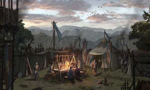 For the Woodland Vales system, I really want to players to set up proper base camps while exploring a stretch of wilderness, where they can store their food and other supplies, as well as the heavy treasures they find under the guard of their hirelings who also take care of the pack animals. Using a more severe interpretation of what constitutes a safe place for the purposes of resting immediately makes this a much greater necessity without really touching the rest of the Dragonbane rules at all.
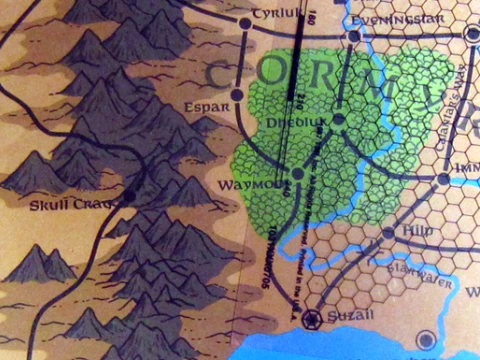
 Encumbrance in D&D has always ranged from bad to terrible. The idea behind encumbrance is actually great. The default assumption for the first decade or so had been that the party enters a dangerous place, gets their hands on valuable stuff, and gets back out again, preferably with their loot and without anyone dying. When wandering monsters are a thing (look forward to part 3) and fighting battles is a negligible source of XP (look forward to part 4), then getting in and out quickly is of the essence. The longer it takes you, the greater is the risk of anyone dying with no benefit in trade. So as you keep delving deeper into the dark unknown, you are using up some of the tools and supplies you have brought with you, but at the same time get weighted down by the treasures you find. Which leaves you with two choices. Slow down and risk fighting more opponents and reducing your odds of being able to run away. Or reduce your weight, either by choosing to leave some of the treasure you’ve found behind, or by dropping some of the equipment that you hopefully won’t be needing on your way back to the surface. Hang on to all your potentially life saving tools and weapons as you slowly crawl back to the exit, or make a mad dash to safety? Or play it safe and leave some of your hard fought for rewards behind? This is a real question that players will have to face. There is no right answer which two out of these three you should choose and will greatly depend on the constantly changing situations. To me, this is one of the big things that make exploration adventures so exciting.
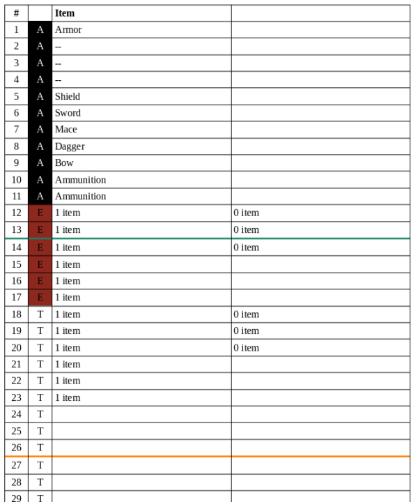
 I have a long and very conflicted relationship with hex maps, which I attribute primarily for my distaste of hexcrawl campaigns and my appreciation of