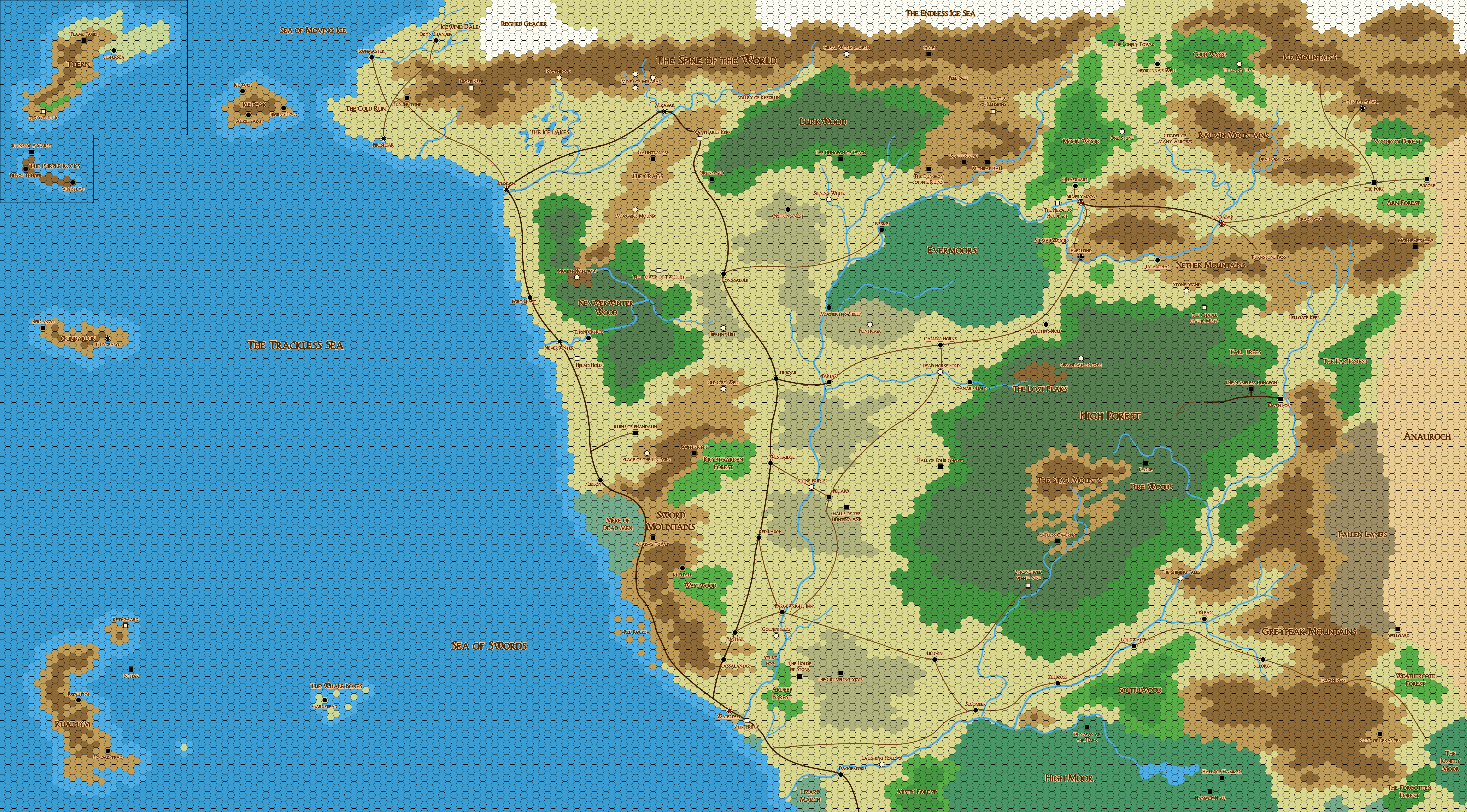
Even with the maps of this region certainly being the fantasy map I’ve been studying the most throughout my life, I was surprised at what details you can discover while drawing a copy of it by hand and thinking about the implications they could have for the various settlements and the people who inhabit them.
Volo’s Guide to the North divides the North into a set of five sub-regions, which I largely agree with as being an obvious system or organize the primary landscapes and patterns of settlement. I would make some changes to the specific boundaries, split the Coast into two separate regions, and also consider the islands of the Trackless Sea an additional region to be counted as part of the Savage Frontier. Concentrating only on the human and dwarven settlements, my classification looks like this:
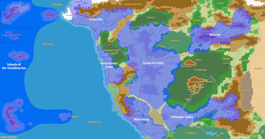 The first very distinctive region is the Islands of the Trackless Sea. While geographically removed by some distance, Luskan, Neverwinter, and Waterdeep are the closest major ports on the mainland and the Northmen sailors of the islands are very important players in the maritime trade and warfare of the northern Sword Coast. The most important island by far is Ruathym, followed by the Gundarlun, Tuern, the Purple Rocks, and the Ice Peak. These are sub-arctic island similar to Iceland, the Faroes, the Shettlands, and the Orkneys with a very much Viking inspired culture.
Next is the Frozenfar, which Volo defined as the towns north of Luskan, but I think should consider this largest port in the far north as well. Besides Luskan, important towns are the great mining city Mirabar in the Spine of the World, the dwarven city Ironmaster, Fireshear, and the Ten Towns of Icewind Dale. Aside from sizable numbers of dwarves, the population here consists mostly of the same Northmen who are native to the Isles of the Trackless Sea. It is also the main hunting grounds of the Black Raven and Grey Wolf tribes of the Uthgardt barbarians. I do not believe that there is any meaningful agriculture happening in these parts and so food will primarily come from fishing in the sea and rivers and from raising sheep. With Mirabar, Ironmaster, and Fireshear being major mining towns, they probably trade much of their metal exports for food from cities further south. While the port of Luskan is certainly more famous, it’s population of 16,000 people is significantly exceeded by the 23,000 of Mirabar.
Continuing south, we come to the region that I uninspiringly call the Neverwinter Coast, following the Neverwinter Woods and surrounding the city of Neverwinter on the Neverwinter River. Aside from Neverwinter with a population of 17,000 people, it also includes Leilon to the south with 3,000 people, and the village Port Llast. The village got its name from being the northernmost human port on the Sword Coast at a time when the site of Luskan was controlled by orcs. Neverwinter is also always giving the impression of being much more similar to Waterdeep and Baldur’s Gate than to neighboring Luskan, which makes me believe that it’s population is more closely related to the people of the South and that the Frozenfar region was settled by Northmen from the islands at a later point. This is the primary reason of why I consider this part of the coast to be a distinctively separate region from Luskan. Being flanked by the Neverwinter Wood instead of the Spine of the World, I also think that this region has much more of a logging industry than mining. The famously mild climate along the warm Neverwinter River also allows for agriculture of a type that isn’t possible in the lands further north.
Further down lies Waterdeep. While also part of the Sword Coast, the large Mere of Dead Men and the Sword Mountains create a large gap of rugged wilderness between the city and Leilon on the Neverwinter Coast. The city itself is one of the great oddities of the Realms. Despite being rather remote and isolated from the Heartlands and the very last outpost of what could generously be considered the civilized world, Waterdeep is widely considered to be the largest city north of the Sea of Fallen Stars with a population of over 100,000 people. The reason for the city’s prosperity is that all the trade from the Savage Frontier has to go through it’s port. Even most caravans traveling south along the road through Daggerford have to pass through it. How far the Waterdeep region stretches to the North is very debatable. There are good reasons to count Goldenfields, Rassalantar, Amphail, and the Bargewright Inn as being part of the Dessarin Valley, but their proximity to Waterdeep surely makes them economically and culturally much more oriented towards the great city than to distant Yartar and Nesme. Their proximity to the coast should also result in much milder winters than the rest of the North is seeing, allowing for a more efficient growing of grain and other crops. I see this region as being a northern outpost of the Western Heartlands and settled by people from that region.
Going up the great river towards the North, we have the Dessarin and Surbrin River Valley. These are part of the great water transport system that connects most of the interior Savage Frontier. The main settlements in this region are Yartar and Nesme with both a population of only 6,000 people. Next comes Triboar with 2,500 people and after that it’s really only a scattering of villages of various sizes. With maps showing the area mostly as just blank land, my interpretation of the landscape is that of the northern parts of the North American Prairies. With Greenwood being Canadian and TSR being located in Wisconsin, it seem likely that this is what the creators had in mind. The Savage Frontier has a map that clearly shows that this is cattle county. Endless expanses of grass from horizon to horizon is perfect for raising grazers, which make for a great food source to feed this otherwise harsh and inhospitable land. You’ll be seeing enough beef and cheese to last you for a substantial part of your remaining life. As with most of the coasts, I see this region as being settled primarily by people from the Western Heartlands. The plains east of Yartar are the lands of the Elk tribe, while those between Neverwinter Wood and the Evermoors are home to the Griffon tribe. Both are widely considered to be among the most hostile tribes towards the other peoples of the North. I expect there to be a lot of cattle rustling going on around these parts.
On the other side of the Evermoors lies the flow of the Rauvin River, which Volo calls the Interior. The Rauvin connects the cities Silverymoon, Everlund, and Sundabar, and an old dwarven road continues further east to the great dwarven stronghold Citadel Adbar of King Harbromm, the last true dwarven king north of the Sea of Fallen Stars. This region is dominated mountains, hills, and various forests and should experience brutal winters, but also potentially quite hot summers with warm winds blowing from the Anauroch desert. While this land does not seem well suited for any kind of agriculture, it is still home to many of the region’s largest cities. Sundabar at 36,000 people (including many half-elves and dwarves), Silverymoon at 26,000 people, Citadel Adbar at 14,000 people, and Everlund at 12,000 people. The Moonwood and Cold Wood to the north are the home of the Black Lion and Red Tiger tribes, and the northern edges of the High Forest to the south are the territory of the Tree Ghost and greatly feared Blue Bear Tribe.
The humans inhabiting these remote city are distinctively different from both the Northmen and the people from the Western Heartlands. Like the Uthgardt barbarians, they are one of the surviving peoples from the ancient magical empire of Lost Netheril, as seen quite easily by their black hair. Other than legendary Halruaa many thousands of miles in the far away South, Silverymoon is the last heir of the great magic of Netheril. (It bothers me that this region has no apparent food source to supply four major cities. This is something for which something needs to be cobbled up together at some later point.)
Finally, there is the Delimbyr Valley south of the High Forest. The river itself continues north for several hundred more miles, but the lands between the High Forest and the Greypeak Mountains is barely explored wilderness uninhabited by humans or dwarves. The lower Delimbyr valley is even more sparsely populated than the Dessarin valley, with the largest settlements being Loudwater with a population of 4,000 and Llork with a population of 2,300. There has been some mining going on in the Greypeak mountains, but this has been in decline since the dwarves of the region have increasingly come into conflict with the Zhentarim. The economy of the Delimbyr depends almost entirely on trade caravans from Zhentil Keep that go all the way from the Moonsea around the southern edges of the Anauroch desert and towards Waterdeep. Llork has essentially become a Zhentarim town over the years and more of a caravan stop than a mining town. The location of Loudwater close to the High Forest and Southwood makes it a good candidate for logging, especially for the shipyards of Waterdeep, and the lower parts of the valley should be suitable for both cattle raising as in the Dessarin Valley and growing crops as in the vicinity of Waterdeep. Like the people of the Surbrin river to the North, the native inhabitants of Llork and Loudwater have the dark hair of Netherese descendants, but no other signs of that great ancient civilization still exist. As one moves down the river to the west, these native people begin to blend together with the new settlers from the South.
 The ancient borders of Eaerlann, Netheril, and Delzoun are fairly well described in the material. In contrast, the borders of Illefarn and the Fallen Kingdom are only mentioned very vaguely and the outlines here are purely my own personal guess.
 I have never actually seen any maps showing the areas that the Uthgard tribes are calling their homes. All we’ve ever been given explicitly are the locations of their holy ancestor mounds and the towns of Griffon’s Nest and Grunwald. However, the descriptions given on each tribe in The Savage Frontier does provide quite a bit information to work with, which resulted in this interpretation of where the Uthgardt would commonly be encountered. Not much information is given on the way the Uthgardt live, but it appears that they do not practice any kind of farming, and so probably rely on a combination of hunting, gathering, and possible some herding.
 Since generic default D&D has pretty much been Forgotten Realms for the last 35 years, there really isn’t any need to have a player book that covers the setting specific races, classes, and magic types of the setting. Just use the PHB content as is. Setting specific material should be covered in three regional books: “Sword Coast”, “Heartlands”, and “Unapproachable East”. I think this would cover everything that 98% of all Forgotten Realms fans would care for. I am not saying that nobody has ever played a campaign set in Tethyr or Mulhorand, and in some four decades it surely must have happened once or twice. And while I would actually predict a big outcry that there need to be two or three more books to cover the rest of Faerûn and that those books might even sell somewhat, I would think that barely anyone would ever actually use them to run campaigns. Just have a page in the Sword Coast book dedicated to “Lands of the South” with information on how to make and run NPC merchants from Amn or Calimshan that are visiting ports in Baldur’s Gate or Waterdeep.