A proposal for a river navigation mechanic

Most RPGs I’ve seen mention about navigation that when you’re following a road or river, you automatically get to your destination eventually, and you only need to make rolls for navigation if you’re going cross country or across the ocean.

Yeah. Kind of. But not really.

If you’re on a river and your destination is to just go downstream to the coast or a city you know to be further down the river, then there’s really no way you can get lost. But things look completely different when you’re trying to go up a river and you come across forks where you have to pick going left or right.

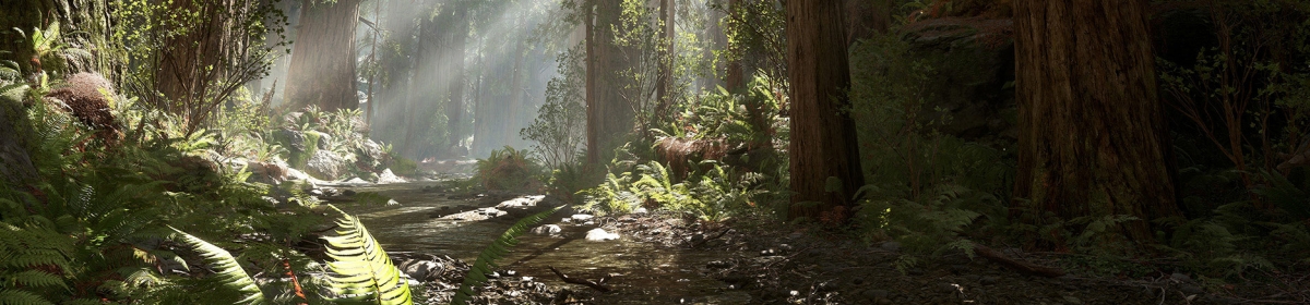
I’ve been on a couple of canoe tours throughout my life, and I’ve been doing the navigation on most of them. Though I have to say that was on very easy rivers in Germany, on waters that have regular traffic and existing infrastructure and very good maps. And we were going to destinations that had been selected by people who knew that those routes would be very easy to follow even to amateurs. And even then, I’ve had many cases where I really had no clue if that big branch to the right is the already the third big branch to the right we need to take, or if one of the branches we already passed looked much bigger in person than it does on the map. The map has an accurate scale on it, but with no means to monitor your exact speed, that’s still only of limited help. Now imagine that deep in the wilderness, following a map drawn by someone with no access to aerial photography or surveying tools.

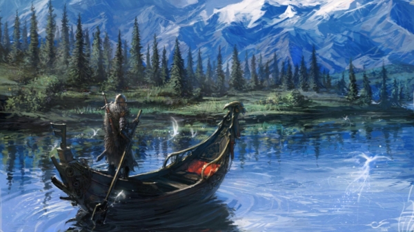
In my rivercrawl campaign, going to a site will almost always consist of going upstream all the way to your destination. And since all wilderness travel will be along rivers, going with the “you can’t get lost when you follow a river” approach isn’t going to cut it. (Though conveniently, getting back to base at the end of an adventure will be very easy, and going with the current also a lot faster.) Something else is going to be needed.

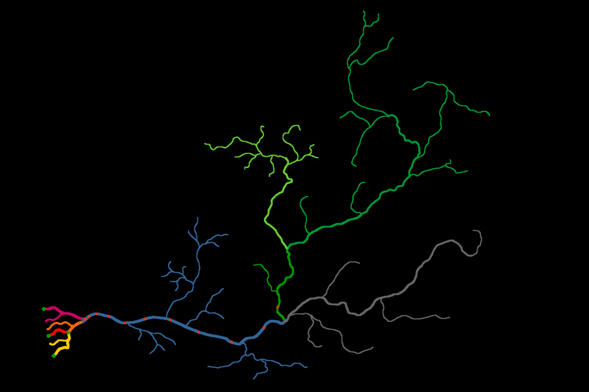
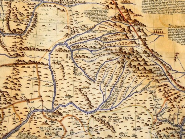
Making a complete map of an entire river system spanning hundreds of miles with all its little side arms really isn’t practical. You could theoretically let players give it a shot on a blank hex map with very small hexes, but I think that would be very tedious and not feel like it reflects the kind of maps actual river explorers would be using for their notes.

Instead, I want to go with an entirely skill check based system to navigate through the networks of small side branches that fork of from the main waterways that are depicted on the main overview map. My own GM map only shows branches up to the third order, and I intend to let players find their ways on those without navigation checks. It’s only for the rivers even smaller than that that this system comes into play.

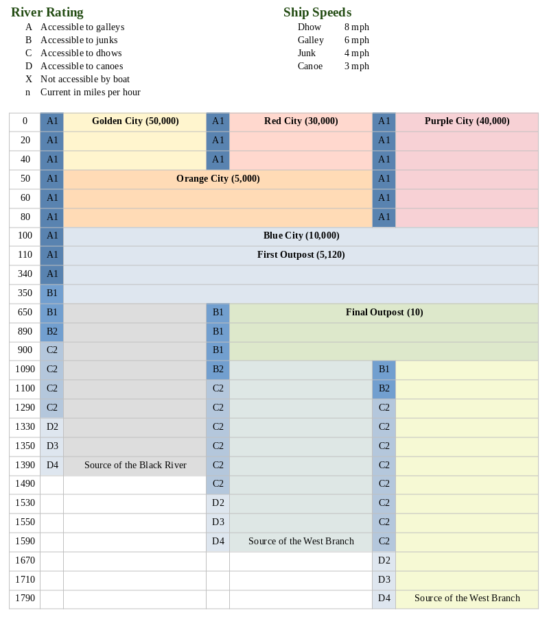
Maps are items that characters can find or sell that have instructions on how to reach certain hidden places from an easily recognizable and unmistakable landmark. Every map has a dificulty based on it’s quality. Using a very good map is an easy task, while using a poor quality is a very hard task. The difficulty is further modified by how far the destination is from the clearly identified reference point on the main rivers. Since I have all my travel times in increments of 10 miles, (1 mile per hour times 10 hours per day), I increase the difficulty of the navigation check by +1 for every 10 miles that you try to follow the map.

If the navigation check is a success, the party reaches the destination in the shortest time possible given the distance and their travel speed. If the check is a failure, they still get to their destination, but for each number that the check fell short of the difficulty, the travel duration is increased to require one additional random encounter check. I do three random encounter checks for each day of travel, plus one check per night. So missing the difficulty by three adds a whole day on the water searching and backpaddling, and you also get another night to rest and potentially have another encounter before you arrive at your destination. Since I usually have random encounters at a chance of 1 in 6 for every check, getting two or three checks added to the journey generally shouldn’t be much of a problem. But for journeys deeper into the smaller rivers, having someone with a good navigation skill and paying for high quality maps can become really appreciated.

The fun part comes with the additional use for navigation checks to make your own maps of the unknown rivers you explore. These maps can be very important if you want to find a place again after having left it, and can be sold to other characters. To make such a map, a character makes a navigation check. The quality of the map and the difficulty to use it depends on the result of the navigation checks. For Worlds Without Number, I’ve decided to make it 20 minus the navigation check result, with the minimum difficulty being 6.

WWN makes skill checks with 2d6, so I think it’s a great idea to let the player roll one of the d6 either open or in secret, and the other d6 gets rolled by the GM. That way the player has a clue for the final quality of the map, but can not be certain how accurate it really is. The ultimate difficulty for using the map remains secret for the GM, at least until the players trying to navigate with the map have reached the destination and will have found out for themselves.

For players going to discover unknown sites by going into these small rivers blindly, one simple approach would be to simply roll a d20, and the result is the number of random encounter checks until the party finds either a small randomly generated site or a larger site whose exact location on the river has remained undefined until a party randomly discovers it. Since you might always need a monster lair or pirate camp if players try to track randomly encountered enemies back to their hideouts, it’s a general good idea to have a couple of those ready at hand anyway. And players can be required to tell the GM that they plan to go on a random exploration a few days before the game.

Ducks of Doom

What are they doing at night in the park?
Think of them waddling about in the dark.
Ducks! Ducks!

Sneering, and whispering, and stealing your cars,
Reading pornography, smoking cigars!
Ducks! Ducks!

Nasty and small, undeserving of life,
They sneer at your hairstyle and sleep with your wife!
Ducks! Ducks!

Wings of Watery Death

Most people agree that geese are evil spawn of the devil, and for good reasons. But there are far more sinister feathered fiends lurking in the reeds flanking the Great River. The gavir looks like a black and white duck from a distance, but nothing could be further from the truth. Its strong beak ends in a sharp point like a woodpecker, which it uses to impale fish, salamanders, lizards, crabs, and even the occasional other water birds or really anything that gets too close. Usually it will swallow its prey whole, but can also seen pecking away at the carcasses of much larger creatures like vultures.

They are always watching. Silently judging you.

When seen close up, which generally should be avoided, a gavir has many resemblances with cranes, as well as snakes and otters. But most striking about it are its red eyes that are filled with malice and hatred for all other living things. While even its head looks similar to that of an ordinary duck, its eyes are in fact forward like the predator it is. Its duck-like body also conceals its true size, which is closer to that of a swan.

Death on Silent Wings

Unlike ducks, gavirs are fast and nimble fliers and much more silent when they attack their unsuspecting prey. The only upside of gavirs compared to other birds of prey is that their feet are lacking the sharp claws found on hawks and owls. However, their duck-like feet make them excelent swimmers and they sometimes ambush their targets by leaping out from under the water when they are not in the mood to attempt chasing intruders away.

Gavirs are extremely agressive and territorial, attacking everything getting close to their nests. While their beaks can’t get through the hides of large ubas or crocodiles, gavirs will often resort to attacking their eyes to drive them off. The presence of large one-eyed predators is often an idication of gavirs in the area. As often as not, such confrontations end with the gavir getting eaten, but that doesn’t appear to deter these rampaging birds. The only other creatures they tollerate are other gavirs. Fortunately, gavirs are rare in the warmer waters of the Lower River, but they are a serious threat to travellers going up the Green River.

Their terrifying red eyes and raging demeanor has many people regard gavirs as demons, but their fury is obviously not fueled by the fires of the Underworld. Like all aquatic monsters, gavirs are spirits of the water, though such violent agression is rarely seen in any others of their kind.

Gavir chicks are no less lethal than fully grown adults.

Gavir: 1 HD,  AC 12, Atk +2 (1d4; 1/15), Move 60, ML 10, Skill +1, Save 15. Gavirs are unnaturally resilient in a fight and completely shrug off smaller injuries, making them immune to suffering shock damage.

Peace was never an option.

The Great River, v0.2

Click to embiggen

This is literally the same river as in my previous diagram, but now made to look like an actual river. It’s composed of maps of actual rivers at different scales, some rotated or mirrored. Green dots are cities, orange dots are trade posts.

Once I overlayed a hex grid in GIMP and set it to correspond to 100 miles for the river delta, I was able to count the actual distances, and it turned out that just by eyeballing, I got amazingly close to the numbers I had drawn up with no references yesterday. The Black River and Western Green River are 200 miles shorter than I had planned, but the length of Eastern Green River and the junctions of the main branches are all only 10 miles off from what I wanted. For reference, the Black River and the Lower River are based on the Mississippi at half-length, so it’s still a really big river.

I’m not quite happy with many of the side branches and will probably bend the Black River more south to make room for a big mountain range between it and the Green River, and maybe turn the Western Green River more southwest, but other than that I am really happy with this for a first attempt.

Mapping a River for pointcrawling

While tinkering further on my Rivercrawl idea, I cam up with this notation to map a huge river network.

First I made a Melan diagram of the main river branches for my river and marked the branches in different colors, which then looks like this.

I then turned the same information into a big table. Below you have a heavily cropped down version to show the principle of how it works. The real thing I made actually has 180 rows over five pages, but most are still completely empty at this point. The principle is basically the same as in Ultraviolet Grasslands, but without the illustrations. I find this easier for river that curves and fans out, compared to the more or less straight trade routes in UVG, and it also allows to make more notes without making a huge unreadable mess. As a tool for GMs to use at the table, I think this plain look isn’t a bad thing.

Getting the whole thing set up was a bit tricky, so here’s how I did it: Since I have only three main branches at any given point of the river, I made a table with seven columns. I think you could also do it with four branches and fit nine columns on one page, but more than that probably makes the thing more a nuisance to read than a help. I found that my river has seven different combinations of parallel running branches, so I made the table with seven rows as well. At this point you first set the column widths that you want, because this will be a total bitch if you try adjusting those later. After that you merge cells together as the river branches fork and meet, which in my case looked like this.

At this point, you can simple select and row and use “add rows below” or whatever your program calls it, and you should get an identical row to the one that you had selected. Then add mile markers to the leftmost row, and you’re done.

Now to the new neat feature that I actually came up with myself. The River Ratings. Each river section row has a little field on the left side that quickly shows the GM the water conditions the players are moving into. It’s fairly self-explaining when you look at the legend above. The letter says what size categories of ships can enter that section of the river. In case of my emerging setting, it’s galley size, junk size, dhow size, and canoe size. Ships larger than that will get stuck on the bottom of the river. (The width of the river or any obstacles in the water are not considered as a separate factor for the sake of convenience. Either your ship can continue on, or it gets stuck on something.) The number indicates the speed of the current. This number is added to your ship’s speed when you travel downriver, and subtracted when you travel upriver. If the speed of the current reduces your speed below 1 mile per hour, you can’t continue by water. I had been thinking to mark the type of terrain on the riverbanks as well to calculate overland speed, but that would mess the readability of this format with too much clutter. For the setting I want to make, it’s going to be “dense forest” pretty much everywhere anyway. I did a bit of looking around for average speeds of the boat types I listed, and the numbers I went with seem to be quite realistic. They are actually leaning to the lower end, as I suspect the original numbers were based on strong ocean breezes, so it would be slower further inland.

My plan for the campaign is that there is an adventuring season of 8 month, which is then interrupted by a flood season of 4 month, where the water speed is simply too much along the whole river to get upstream. I think it would be cool to make a roll at the start of each new adventuring season to see if water levels are exceptionally high or low this year. A high river increases the size rating for the whole river by one, while a year of low water levels reduces it by one. The players might find that the expedition they had planned either needs to be canceled or attempted with a much smaller boat as the river conditions make reaching the destination in a junk or dhow impossible. You could also have a randomly determined special event that changes the water level or speed halfway through the season, which can lead to very inconvenient complications hundreds of miles away from civilization.

Row, row, row your boat, bravely up the stream

So, if you have a setting idea that is not centered around kingdoms and cities, what other reference frames can you use to give structure to the peoples and societies of a vast wilderness setting? How about rivers? All the earliest civilizations of the Bronze Age first appeared along the largest rivers in the old world because big rivers are really really useful. They provide a steady source of water, which in the sub-tropical zones where you find these civilizations can otherwise be quite a problem. But they are also extremely useful for transportation. Rivers allow you to transport large quantities of cargo just as easily as by rail. Load all the stuff on a boat, add a sail or go with the current, and wait until you’ve reached your destination. If you have goods to move, rivers are the way to go. Or to float. While water isn’t as much a problem in Central Europe, the region between Germany and France has been constantly contested for many centuries because it’s the origin of the Rhine, the Seine, and the Rhone, having easy access to the North Sea, Atlantic, and Mediterranean.

It’s been one of the design elements for Planet Kaendor very early on that all civilization has to be on rivers or the coast, with the deeper forests being more or less inaccessible for heavy cargos. When I was thinking of city states, I was mostly thinking about the coasts and large ports, but that’s not where the adventure is. Adventure is deep in the forests where the ancient ruins are hard to get to. I am now thinking about moving all the pieces on the map to correspond to three huge river systems and one archipelago of islands of the coast. I really like ocean beaches, but Planet Kaendor is meant to be a forest world foremost. While there won’t be any along the major rivers, there’s more than enough in the islands region. While I have plans for a sub-arctic and a tropical forest set in Kaendor, for practical reasons it makes the most sense to only go with the temperate-subtropical one for now. I think any single campaign is best served by being based entirely on a single river.

The Setting

Since this first river is located in what I used to call the Dainiva forest, I’m going to call it the Dainiva river here for convenience. And since nothing is a permanent as a temporary fix, that’s probably now going to be its name forever. The great Dainiva river has been the home to many great civilizations over the ages. Cyclopean castles of the giant Rock Carvers overlook the river from cliffs towering over the meandering courses of the upper rivers, with the lower river being home to many old Naga cities. Ruins of the sorcerous Tower Builders rise above the dense trees flanking the river banks, as well as the magnificent living citadels of the Tree Weavers. All these civilizations have long ago faded from history, and it was many centuries after the Naga retreated to the jungles of the south that mortal peoples began settling on the lower banks, gradually but cautiously moving into the abandoned palaces of the serpentmen. Among the ruins they discovered the arts of casting bronze and mastering the secrets of alchemy, leading to the rise of the first mortal civilization. Over many centuries and generations, explorers ventured further up the waters, but even a thousand miles upstream, there were still no signs of the headwaters of the major branches. Only more water and trees, and the wrecks of explorers who had gone before them. And more ruins and monsters.

The Map

A setting of this type is perfectly suited for pointcrawls. Since travel is basically linear along the river branches or their banks, and ruins have to be visible from the river for characters to have any chance to find them, using a hexmap would not provide any actual benefits. Instead, a map showing the various main branches can show the distance between any fork, settlement, and ruin right next to them, and you can also use color to mark different types of water. For example, the common speed for rowing a canoe with no current is given in most places as 3 miles per hour. Currents of 1 or 2 miles per hour also don’t appear to be anything unusual, and while many rivers are much faster, the current generally is slower when you stick close to the shores where it’s more shallow. So you can mark the river conditions in three colors. Dark blue for the slowest water, in which rowers go 2 mph upstream and 4 mph downstream; medium blue for faster water, in which rowers go 1 mph upstream and 5 mph downstream; and light blue for waters too rapid to paddle against, that require continuing on foot. But you could still build a single-use raft from trees and go downstream at 6 mph. If you want to, you can also convert straight from miles per hour to miles per day, if hourly precision isn’t desired, but if you don’t have to deal with things like traveling 2.33 hexes in a day, I think tracking distances by the mile isn’t really any nuisance. On the major branches of a river of this size, there is easily more than enough room to navigate large cargo ships like a junk. With a slightly more sophisticated sail than just a plain square cloth, it is possible to sail up a river against the current, even with quite moderate wind coming from the sides. Merchant ships like these would replace the trade caravans seen in many land-based settings.

Settlements are all either directly on the river or at least have an accessible pier that connects to the actual village by a short path. Since they would want to be visited by traders, such piers would be clearly visible. But you could also have lairs of rivers pirates or secret cults hiding in barely visible side branches much too small for larger merchant ships. With civilization being based along the lower river near the coast, settlements become more scattered and smaller in size as one travels upstream. This can be used as a great indicator for players about the dangers they can expect to encounter. In civilized areas on the lower river, big monsters have long been driven out, but all the best ruins have been picked completely clean generations ago. But on the upper river, few mortals have ever set foot and there are both more dangerous monsters and much greater treasures to be found.

Since traveling on water is relatively simple and allows for the transport of great loads with little effort, I think a campaign of this type works best if you make it really big. Make it a river as big as the Volga, the Mekong, or the Columbia, where characters can go exploring for months between the end of the spring floods and the onset of winter. With the help of rafts, parties will be able to return with huge hauls of treasure, so the journey back to civilization should be a long one to compensate. Bigger hauls should translate to fewer hauls.

Basing a sandbox around a river system is also really convenient for a GM. By its nature, its close to a fractal, allowing you to just keep expanding it with more and more side branches as the party continues exploring upstream. A river map does not have to bother with mountains or elevation, and generally there’s no need to be exact about the width and depth of the water. And if you should end up with a branch that gotten too narrow and shallow to continue on, the party can always go back downstream a couple of miles and go up another branch. Now for the lower river, I think the players should have a map of the main branches and major side branches, as those are areas frequented by river merchants making their regular round. But once you leave civilization behind, there’s no limit for how far you can continue.

Similarly, it’s very easy to create villages and ruins in a vacuum and just plop them down on the map wherever the players decide to go. That goes a bit against the common ethos that players should have control over where they go by making informed choices, but I think in a setting like this, there really are not a lot of choices to make. Check it out or continue up the river? And given how many branches a river system of this size has, I don’t think working with fixed locations would actually be feasible. You’d end up with a lot of “this branch gets too narrow to continue and you’ve not seen any signs of a ruin”. That’s not player agency either. You could very well establish some facts about a ruin when the party stops at a village or trade post and gets a tip from the locals. But there wouldn’t be any need to establish any of this before the party arrives at this part of the river.

Encounters and Sites

I think for a campaign of this type, random encounters might actually the bread and butter of many adventures. Ruins are cool, but when slowly travel up a river for hundreds of miles, you’ll be doing a lot of encounter checks.

In a world with river merchants, you’d also get river pirates. Those pirates would know not to bother explorers going up the river in the spring, unless they are desperate for supplies, but be waiting to pounce at any explorers coming back down the river in the fall with their big hauls of loot. Merchants might invite the party to get a free ride with no paddling on their ships in exchange for protection against pirates while they have the same route. On the upper river, you can have encounters with aquatic and semi-aquatic humanoids, who could either be friendly or hostile to rare visitors from downriver with goods to trade. There can be the wrecks of failed expeditions, which might even be salvageable and be sold for a huge profit if floated down the river without sinking. Or repaired and used for further expeditions the next year. Or there could be ancient crumbling dams from the old civilization that threaten settlements downstream with disastrous floods, allowing for some variation between dungeon crawls.

And then there’s of course the river creatures. Obviously crocodiles and big snakes, but I’m really giddy at the idea of giving players a paralyzing phobia of hippos. Someone suggested to me adding dire beaver dams to block of some rivers and require hauling boats over land to continue. I also really like the idea of creatures in the trees following the players in their boats from shore, waiting for an opportunity to attack.

It really is a fairly simple concept for a sandbox setting, but one I think has huge potential, while looking very manageable at the same time.