
While tinkering further on my Rivercrawl idea, I cam up with this notation to map a huge river network.
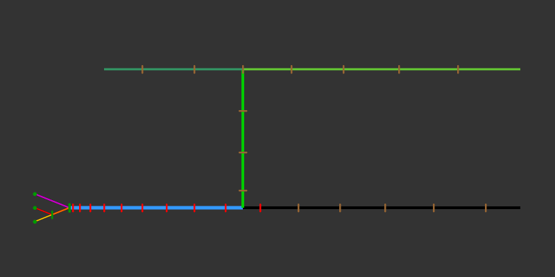
First I made a Melan diagram of the main river branches for my river and marked the branches in different colors, which then looks like this.
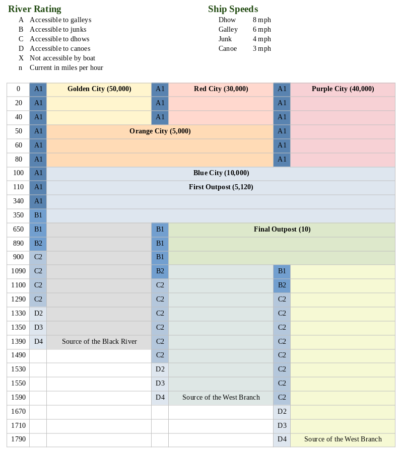
 I then turned the same information into a big table. Below you have a heavily cropped down version to show the principle of how it works. The real thing I made actually has 180 rows over five pages, but most are still completely empty at this point. The principle is basically the same as in Ultraviolet Grasslands, but without the illustrations. I find this easier for river that curves and fans out, compared to the more or less straight trade routes in UVG, and it also allows to make more notes without making a huge unreadable mess. As a tool for GMs to use at the table, I think this plain look isn’t a bad thing.
 Getting the whole thing set up was a bit tricky, so here’s how I did it: Since I have only three main branches at any given point of the river, I made a table with seven columns. I think you could also do it with four branches and fit nine columns on one page, but more than that probably makes the thing more a nuisance to read than a help. I found that my river has seven different combinations of parallel running branches, so I made the table with seven rows as well. At this point you first set the column widths that you want, because this will be a total bitch if you try adjusting those later. After that you merge cells together as the river branches fork and meet, which in my case looked like this.
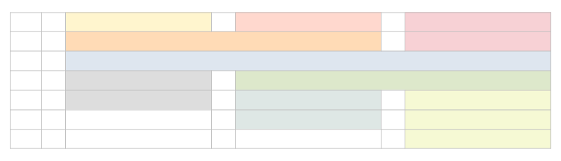 At this point, you can simple select and row and use “add rows below” or whatever your program calls it, and you should get an identical row to the one that you had selected. Then add mile markers to the leftmost row, and you’re done.
Now to the new neat feature that I actually came up with myself. The River Ratings. Each river section row has a little field on the left side that quickly shows the GM the water conditions the players are moving into. It’s fairly self-explaining when you look at the legend above. The letter says what size categories of ships can enter that section of the river. In case of my emerging setting, it’s galley size, junk size, dhow size, and canoe size. Ships larger than that will get stuck on the bottom of the river. (The width of the river or any obstacles in the water are not considered as a separate factor for the sake of convenience. Either your ship can continue on, or it gets stuck on something.) The number indicates the speed of the current. This number is added to your ship’s speed when you travel downriver, and subtracted when you travel upriver. If the speed of the current reduces your speed below 1 mile per hour, you can’t continue by water. I had been thinking to mark the type of terrain on the riverbanks as well to calculate overland speed, but that would mess the readability of this format with too much clutter. For the setting I want to make, it’s going to be “dense forest” pretty much everywhere anyway. I did a bit of looking around for average speeds of the boat types I listed, and the numbers I went with seem to be quite realistic. They are actually leaning to the lower end, as I suspect the original numbers were based on strong ocean breezes, so it would be slower further inland.
My plan for the campaign is that there is an adventuring season of 8 month, which is then interrupted by a flood season of 4 month, where the water speed is simply too much along the whole river to get upstream. I think it would be cool to make a roll at the start of each new adventuring season to see if water levels are exceptionally high or low this year. A high river increases the size rating for the whole river by one, while a year of low water levels reduces it by one. The players might find that the expedition they had planned either needs to be canceled or attempted with a much smaller boat as the river conditions make reaching the destination in a junk or dhow impossible. You could also have a randomly determined special event that changes the water level or speed halfway through the season, which can lead to very inconvenient complications hundreds of miles away from civilization.