When creating a “world map” for a fantasy setting, I generally find it rather pointless to actually make a map that shows the entire world. Most fantasy worlds aim to be late medieval to early modern in the kind of world they describe and in these time periods much of the Earth was yet unknown even to the people with the most complete maps that existed. Also, an Earth-sized planet is massive and there is no way you could ever actually visit all those places, no matter how many books you write or games you play. At the very most, what a setting can practically make use of, is a region that covers all the major climate zones and ecological environments.
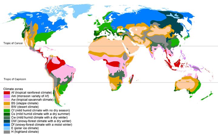 While the distance from pole to pole is a bit over 20,000 km, the north to south length you need for a map that provides all the environments you could ever wish for is much shorter than that. I took some measurements on world maps and the numbers that showed up again and again were all in the range of 3,000 to 3,500 km. Or in fantasy units, 2,000 miles.
It is the distance that takes you from the northern coast of Africa to the northernmost extend of the Baltic Sea. It’s the distance from Russia across all of Mongolia and China to northern Vietnam. It’s from Hudson Bay in Canada to Cuba and from Alaska to Baja California. The distance from Rio de Janeiro to the Falkland Isles.
If you really want the full range of possible climates from the thickest tropical jungles to the permanently frozen artic tundra it’s more like 3,000 miles, but with 2,000 you are already on the pretty safe side in your ability to cover any landscapes you might want to put into your world.
Exactly. A while back I had was thinking about scale and used the size of the Earth’s continents as a guide. I needed a single continent large enough to have environments that felt massive in scale, and left with the note “The Furthest Lands are 2,200 miles across, the Great Plain (the far largest environment) 1,300.” Seemed the right amount of room to do whatever one wanted, it’s neat seeing your thought process on this, .
I have not shown a recent map of my Ancient Lands for some considerable time now. But it basically is a coast that runs from North to South with all the big settlements near the sea. While it looks relatively big, the actually used space is just one long narrow strip in an S-shape 3,000 miles long and 500 miles deep. That’s an effective area of 1.5 million square miles, about the size of India or the EU.
I’m glad someone thought to actually figure this out. That’s legitimately useful information.
(I’ve always disliked fantasy maps that show full continents sea-to-sea – let alone ALL continents on a world!)