Pathcrawls

We are now resuming our irregular schedule.
I’ve never been friends with the idea of hexcrawling. Lots of people fill the term with all kinds of different meanings as long as there is at least one hex map involved somewhere, but to me it always carries the clear meaning of being the same concept as dungeoncrawling, translated from dungeon rooms to wilderness hexes. Which means the players are going from hex to hex, color in the new hex on their map as the terrain type they discover, and ask the GM if they see anything that they can check out. Like the player map for The Isle of Dread.
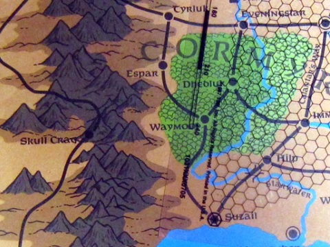
Some people will say that hexcrawling is much more than that, but there’s plenty of people around who strongly assert that every single hex should have something in it to discover, so the idea is there. That just doesn’t sound very fun to me, as it easily turns into wandering around aimlessly waiting for something to happen. I also think it breaks the believability of the world as a 24 square mile area is massive and you could spend month exploring just a single 6-mile hex without ever spotting a cave, statue, or tower that is somewhere between the hills and trees. As I outlined in a previous post, I think it is much more plausible for PCs to find new sites when they either have instructions for how to reach them, or they are visible from a road or river the party is travelling on. In many ways, this is simply a pointcrawl. But there are various things about the pointcrawl map as originally proposed that I find inconvenient for how I want to run my campaigns. Where do you put boxes for new sites that are added to the world as a consequence of players tracking randomly encountered creatures to their lair or base without messing up the map? What if players decide to take shortcuts through woodlands or swamps where there are no roads or rivers to follow? These issues can be quite easily fixed without really overturning the whole system, so consider this a tweak on pointcrawl maps.

First thing is to draw the map for the area in freehand with no grid. (Even the hexmaps I posted recently started that way before I added the hex grid.) Primarily coastlines, mountains, rivers, lakes, and swamps, and such things.

Second, add the major settlements, strongholds, and ruined cities to the map.

Third, draw the roads that people build to connected these settlements.

Now that we have the main rivers and major roads, as the fourth step, add any other sites that people in the area might have discovered already and could give the players instructions on how to find them.

Fifth, add the secondary paths that connect these sites to the main roads and rivers.

Now we know all the paths through the region that parties are likely to travel on. As the sixth step, add sites that could be spotted by simply traveling on one of the primary and secondary paths.

Seventh, mark paths that connect those tertiary sites to the road and river network. Since characters can see those sites from the road, they don’t need any kind of trail to follow. Just keep it in your sight and move towards it. Depending on the granularity you want with distances, these can even be marked as being right on the trail from which they can be spotted.

Only now comes the step to add a hex grid to the whole map. This hex grid is not to divide the wilderness into segments, but simply as a visual aid to easily estimate the length of swirling paths as they meander through the environment. If you’d want to, you could just note the distances between two points next to the path of the map and remove the grid again if you’re working with a digital map. Back in the day, the 2nd edition Forgotten Realms Campaign Setting box had a hex grid printed on a sheet of clear plastic at the same scale as the maps in the box for just that purpose. I think any print shop would still be able to make such a sheet for you if you have an apprpropriately scaled file of a hex grid on a USB stick.

The advantage of making a wilderness map like this is that I can easily add more dots and more lines to the map, and since the map is based on physical geography instead of a flow-chart abstraction, I can determine the length of any new path easily by counting the number of hexes it passes through. If the players say “You know what, we get off the trail here and just keep heading straight south until we reach the river and then follow it downstream to the town”, it’s trivial to figure out the length of the path, though it would be something you’d have to purely handwave on a default pointcrawl map.

Which might of course be a complete non-issue for many people. This is simply my method that I am using to get the mix of abstraction and precision that I find ideal for my campaigns.

Mapping a River for pointcrawling

While tinkering further on my Rivercrawl idea, I cam up with this notation to map a huge river network.

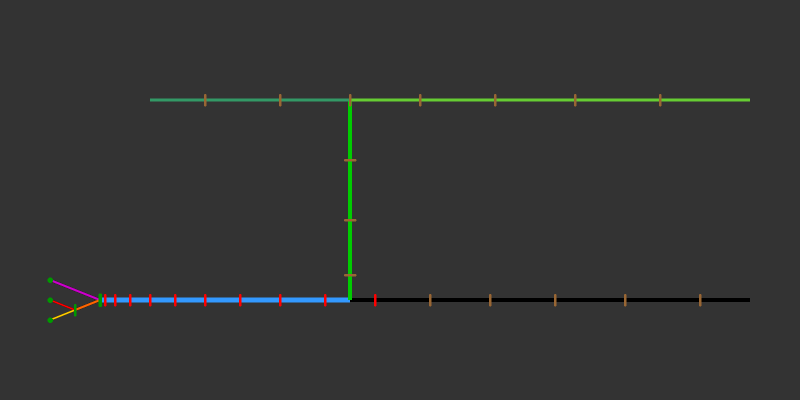
First I made a Melan diagram of the main river branches for my river and marked the branches in different colors, which then looks like this.

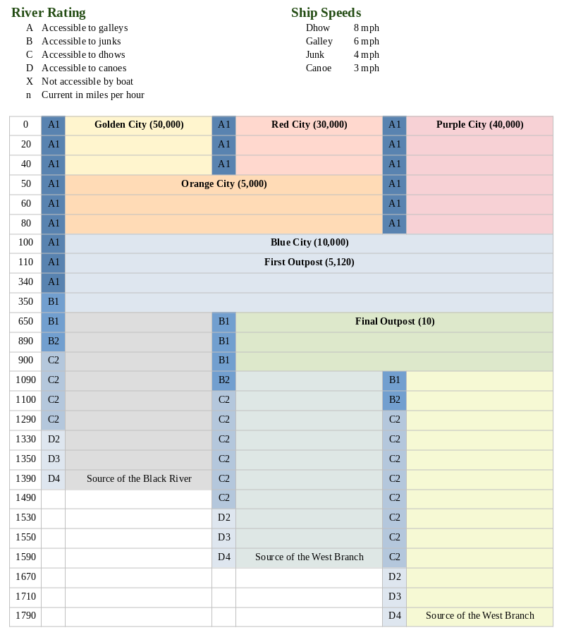
I then turned the same information into a big table. Below you have a heavily cropped down version to show the principle of how it works. The real thing I made actually has 180 rows over five pages, but most are still completely empty at this point. The principle is basically the same as in Ultraviolet Grasslands, but without the illustrations. I find this easier for river that curves and fans out, compared to the more or less straight trade routes in UVG, and it also allows to make more notes without making a huge unreadable mess. As a tool for GMs to use at the table, I think this plain look isn’t a bad thing.

Getting the whole thing set up was a bit tricky, so here’s how I did it: Since I have only three main branches at any given point of the river, I made a table with seven columns. I think you could also do it with four branches and fit nine columns on one page, but more than that probably makes the thing more a nuisance to read than a help. I found that my river has seven different combinations of parallel running branches, so I made the table with seven rows as well. At this point you first set the column widths that you want, because this will be a total bitch if you try adjusting those later. After that you merge cells together as the river branches fork and meet, which in my case looked like this.

At this point, you can simple select and row and use “add rows below” or whatever your program calls it, and you should get an identical row to the one that you had selected. Then add mile markers to the leftmost row, and you’re done.

Now to the new neat feature that I actually came up with myself. The River Ratings. Each river section row has a little field on the left side that quickly shows the GM the water conditions the players are moving into. It’s fairly self-explaining when you look at the legend above. The letter says what size categories of ships can enter that section of the river. In case of my emerging setting, it’s galley size, junk size, dhow size, and canoe size. Ships larger than that will get stuck on the bottom of the river. (The width of the river or any obstacles in the water are not considered as a separate factor for the sake of convenience. Either your ship can continue on, or it gets stuck on something.) The number indicates the speed of the current. This number is added to your ship’s speed when you travel downriver, and subtracted when you travel upriver. If the speed of the current reduces your speed below 1 mile per hour, you can’t continue by water. I had been thinking to mark the type of terrain on the riverbanks as well to calculate overland speed, but that would mess the readability of this format with too much clutter. For the setting I want to make, it’s going to be “dense forest” pretty much everywhere anyway. I did a bit of looking around for average speeds of the boat types I listed, and the numbers I went with seem to be quite realistic. They are actually leaning to the lower end, as I suspect the original numbers were based on strong ocean breezes, so it would be slower further inland.

My plan for the campaign is that there is an adventuring season of 8 month, which is then interrupted by a flood season of 4 month, where the water speed is simply too much along the whole river to get upstream. I think it would be cool to make a roll at the start of each new adventuring season to see if water levels are exceptionally high or low this year. A high river increases the size rating for the whole river by one, while a year of low water levels reduces it by one. The players might find that the expedition they had planned either needs to be canceled or attempted with a much smaller boat as the river conditions make reaching the destination in a junk or dhow impossible. You could also have a randomly determined special event that changes the water level or speed halfway through the season, which can lead to very inconvenient complications hundreds of miles away from civilization.

Pointcrawling in a Dungeon!

Formulating my thoughts on a subject always helps my putting my ideas into focus. And so after writing yesterday about the challenges of using a pointcrawl map for a large dungeon I came up with some new ideas for how this problem might be solved.

Pointcrawling really is all about navigation by landmarks or travel along marked paths. During overland travel this is usually the only way there is to pick where you are going. This makes is very easy to take a hex map and convert it into a point map by simply removing all the hexes that don’t have keyed sites or encounters or lie along a path that connects two of the keyed locations. And you can easily convert a point map back into a hexmap by simply overlaying a hex grid on the chart of sites and paths.

But with dungeons this is not the same. As people discovered very early on in the history of RPGs, dungeons are very different environments from outdoor landscapes. In a dungeon you don’t chose your path or destination, you can simply go forwards and backwards in a corridor and pick from a fixed number of other corridors at junctions. When you want to go dungeon crawling with a point map, you can’t just take any grid map dungeon and convert it to a point map. This doesn’t work and you only end up with nonsense that has the same complexity as you started with. Instead, you have to design the entire dungeon from the ground up with a point map in mind.

A dungeon that would be very easy to do with a point map is a ruined castle with an open courtyard. In fact, Chris Kutalik’s ruincrawl is really an attempt to explore cities, not buildings. With an open castle, you can have the first area be the gatehouse that has one entrance and one exit. Once the players reach the exit of this area they can overlook the courtyard and see the various buildings that make up the interior. There may be a keep, a chapple, stables, a tavern, a warehouse, an inner gatehouse, and lots of uninteresting small sheds. The sheds and the patrol corridors in the walls have nothing interesting in them so they can be ignored and are not getting mapped. The other buildings each get their own small map and are marked on the point map as distinct areas. From their position at the exit of the outer gatehouse the players have a clear path to the stables, warehouse, tavern, and inner gatehouse, and if they go through the inner gatehouse they can also walk over to the chapple and the keep. What the paths in the courtyards look like is irrelevant. That’s a basic and simple pointcrawl.

This doesn’t work in a dungeon that is entirely underground, though. Simply because you can’t see other areas from a distance. You can’t say “let’s go over there” when you can’t see “there” and don’t even know that “there” exists. Ina grid map dungeon this is not a problem since you simply follow the corridors and then see where they lead to. With navigation by landmark being out of the picture, following marked paths is the only remaining option. But the whole point of pointcrawling a dungeon is that you want to strip out all the empty halls and chambers that make up the majority of the place and only have the players interact with the most interesting areas. I think the solution to this conundrum is to design dungeons for a pointcrawl along a network of highways. Coridors that clearly stand out from the rest and serve as main connective routes between major prominent area of the dungeon. Dozens or hundreds of minor side passages branch off from these leading to living quarter and storerooms, but they are not included in the map and can not be actively explored by the players. To look at a part of the dungeon in detail there has to be something that visible stands out and draws the attention of the PCs to the fact that there might be something worth looking at.

This is of course a few steps removed from the complete hands off approach you can have with grid map dungeons where the GM really only tells the players what they see and what happens as consequence of their actions. By designing a dungeon like this the GM takes the previlege to tell the players that their characters are not interested into exploring certain corridors and rooms and that they simply continue on their exploration along the provided path, which might not sit completely well with everyone. But really, this is exactly what outdoor pointcrawls do too. It’s an aknowledging nod towards the fact that games are abstractions of adventures and not accurate simulations. It takes away player choice, but really only choices that the GM knows in advance to be completely irrelevant. I don’t think many players would feel sorry about not having to explore 80 empty rooms in a room before they find a room that has something in it. When you look at fiiction this happens all the time. If you take a book or movie at face value, characters are instantly teleporting around all the time between scenes. But everyone is in agreement that the characters did walk between locations and that they probably talked during that time and perhaps even had some encounters that are completely inconsequential to the story. This is the underlying idea here.

A secondary issue I had been pondering is how to indicate the border of an area when each area consists of multiple rooms and is surrounded on all sides by more or less indentically looking rooms. What I think might be the best approach is to construct the whole dungeon not as one continous cluser of rooms but instead as multiple self-contained cells, which each cells having only two or three exits that lead to other cells. This is one of the things that makes it necessary to design a dungeon as a pointcrawl from the ground up. Grid map dungeons usually don’t have such clear cell structure and a great number of possible connections between thematically linked areas.

A system of self contained grid mapped cells connected by highways running through otherwise nondiscript cells is my solution to having huge dungeons that don’t involve long stretches of tedious searching through empty rooms or being implausibly cramme with treasures and monsters. Or at least my current attempt at a solution.