Pathcrawls

We are now resuming our irregular schedule.

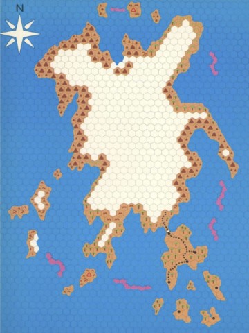
I’ve never been friends with the idea of hexcrawling. Lots of people fill the term with all kinds of different meanings as long as there is at least one hex map involved somewhere, but to me it always carries the clear meaning of being the same concept as dungeoncrawling, translated from dungeon rooms to wilderness hexes. Which means the players are going from hex to hex, color in the new hex on their map as the terrain type they discover, and ask the GM if they see anything that they can check out. Like the player map for The Isle of Dread.

Some people will say that hexcrawling is much more than that, but there’s plenty of people around who strongly assert that every single hex should have something in it to discover, so the idea is there. That just doesn’t sound very fun to me, as it easily turns into wandering around aimlessly waiting for something to happen. I also think it breaks the believability of the world as a 24 square mile area is massive and you could spend month exploring just a single 6-mile hex without ever spotting a cave, statue, or tower that is somewhere between the hills and trees. As I outlined in a previous post, I think it is much more plausible for PCs to find new sites when they either have instructions for how to reach them, or they are visible from a road or river the party is travelling on. In many ways, this is simply a pointcrawl. But there are various things about the pointcrawl map as originally proposed that I find inconvenient for how I want to run my campaigns. Where do you put boxes for new sites that are added to the world as a consequence of players tracking randomly encountered creatures to their lair or base without messing up the map? What if players decide to take shortcuts through woodlands or swamps where there are no roads or rivers to follow? These issues can be quite easily fixed without really overturning the whole system, so consider this a tweak on pointcrawl maps.

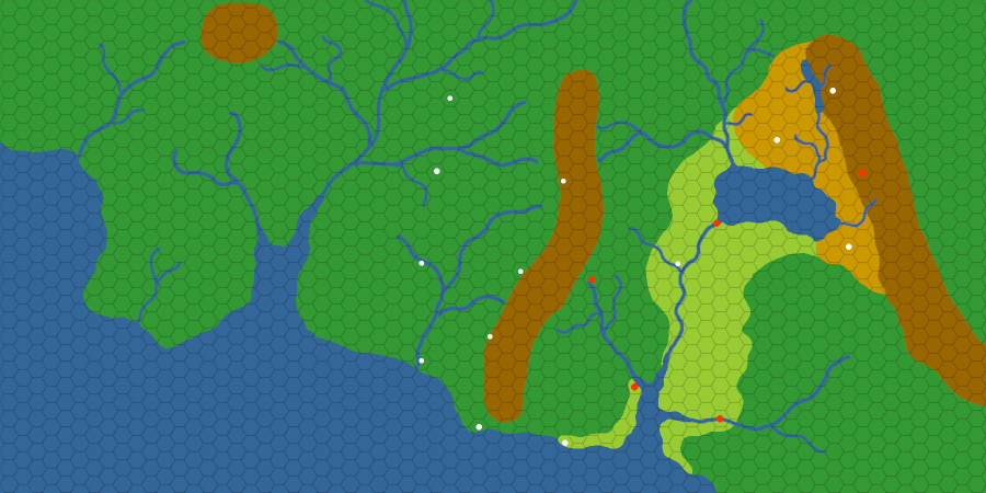
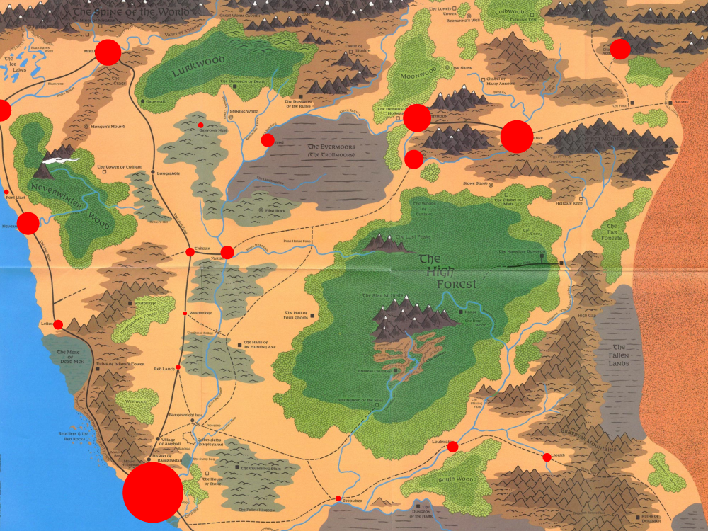
First thing is to draw the map for the area in freehand with no grid. (Even the hexmaps I posted recently started that way before I added the hex grid.) Primarily coastlines, mountains, rivers, lakes, and swamps, and such things.

Second, add the major settlements, strongholds, and ruined cities to the map.

Third, draw the roads that people build to connected these settlements.

Now that we have the main rivers and major roads, as the fourth step, add any other sites that people in the area might have discovered already and could give the players instructions on how to find them.

Fifth, add the secondary paths that connect these sites to the main roads and rivers.

Now we know all the paths through the region that parties are likely to travel on. As the sixth step, add sites that could be spotted by simply traveling on one of the primary and secondary paths.

Seventh, mark paths that connect those tertiary sites to the road and river network. Since characters can see those sites from the road, they don’t need any kind of trail to follow. Just keep it in your sight and move towards it. Depending on the granularity you want with distances, these can even be marked as being right on the trail from which they can be spotted.

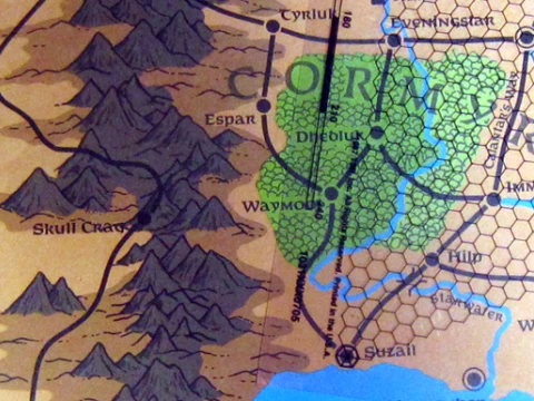
Only now comes the step to add a hex grid to the whole map. This hex grid is not to divide the wilderness into segments, but simply as a visual aid to easily estimate the length of swirling paths as they meander through the environment. If you’d want to, you could just note the distances between two points next to the path of the map and remove the grid again if you’re working with a digital map. Back in the day, the 2nd edition Forgotten Realms Campaign Setting box had a hex grid printed on a sheet of clear plastic at the same scale as the maps in the box for just that purpose. I think any print shop would still be able to make such a sheet for you if you have an apprpropriately scaled file of a hex grid on a USB stick.

The advantage of making a wilderness map like this is that I can easily add more dots and more lines to the map, and since the map is based on physical geography instead of a flow-chart abstraction, I can determine the length of any new path easily by counting the number of hexes it passes through. If the players say “You know what, we get off the trail here and just keep heading straight south until we reach the river and then follow it downstream to the town”, it’s trivial to figure out the length of the path, though it would be something you’d have to purely handwave on a default pointcrawl map.

Which might of course be a complete non-issue for many people. This is simply my method that I am using to get the mix of abstraction and precision that I find ideal for my campaigns.

The latest map and an updated overview of Kaendor

My old computer has been reaching the end of its life and the backup I am using now just doesn’t have the power to handle the large file sizes I usually like to work with, so for the time being I am limiting myself to basic layout sketches without trying to make them look pretty as handouts for players. I also decided to limit the scope of this map to just the part of the continent that I actually need for planning my next campaign.

30 miles per hex, 900 miles by 1800 miles.

This area actually covers a good 90% of all the content that I have already created for the setting. There’s still the far northern lands of Venlat where the white skinned and white haired Kuri live under the rule of Maiv the Witch Queen, but I am quite happy with that being a far off distant land that has no direct contact with the main civilized region shown on this map.

Senkand

On the east side of the map is a huge valley between two mountain ranges with a total size roughly on the same scale of France or Spain. I think that’s as big as I can go with the main city states (maked in red) still having meaningful regular interactions with each other. The eastern mountains and highlands are the lands of the Yao mountain people, while the great plain in the center of the valley is the lands of the Murya sorcerer kings. The woodlands north of Senkand are the home of the Fenhail tribes.

This incarnation of Senkand takes a lot of inspirations from Dark Sun, but instead of a barren desert its environment is more like Northern Spain and southern France, with the mountains being comparable to the Pyreneese and the Alps. In earlier versions of the setting it used to be more like the coasts of Greece and Southern Italy, but in the process of downscaling the city states considerably to make a more wilderness focused setting, I decided to drop the Mediterranean port city model (which is more a think of Antiquity) with the river valley structure that dominated in the Bronze Age.

I don’t have any specific plans for campaigns set in the east and I mostly want it to be background material for NPCs and factions. Though I think it would be a perfectly playable region that still works in the overall style I am pursuing with Kaendor.

Dainiva

The center of the map consists of a large region of temperate-warm woodlands that are bordered in the east by the mountains that separate it from the city states of Senkand, and in the west by a great river that marks the edge of the known world for most people. This area is what Kaendor was always meant to be about and that is most reflective of the kind of environment implied by the Dungeons & Dragons Basic and Expert rules. A vast wilderness full of ruins, monsters, and treasures, and only a few scattered villages and forts.

Dainiva, as well as the forests beyond the great river, were once the realm of the asura who ruled there for thousands of years. Their presence alone was what had kept the various early societies of Senkand from attempting to cross the mountains. But now the asura are almost entirely gone, and the lands of Dainiva have been abandoned for many centuries. The first people to cross the mountains where Murya shamans and witches seeking the occult secrets of the great asura kings. They brought back great amounts of esoteric knowledge about other realms and demons that became the basis of sorcery, but many of them stayed in the lands beyond the mountains to delve deeper into what the asura had discovered before them. Whatever they found, something covered the peaks of the mountains in clouds of poisonous ash and made the few passes crawl with ghouls and other undead horrors. For many generations crossing the mountains was all out impossible, but over time clouds of ash become more rare and the undead only rarely seen. Slowly Murya from Senkand resumed making the crossing into the lands beyond the mountains, while further north some Fenhail and the occasional Yao made the journey through the forest. Most of the people who came to Dainiva and settled down had fled from Senkand for one reason or another, which greately affected the kind of society that developed in the west.

The woods of Dainiva are home to scattered villages of rarely more than a few hundred people, often surrounded by wooden palisades or build on top of defensible hills and cliffs. Hunting is just as much a part of daily life as farming and great amounts of tools and weapons found by local traders have been imported from the East. The woods are also filled with ancient asura ruins, as well as the lairs and tombs of the first sorcerers.

Beyond the Great River

While the woodlands of Dainiva are a barely explored frontier, the lands on the western bank of the great river are a completely unknown wilderness. Rumors are that those distant forests are still ruled by asura kings, the mountains swarming with dragons, and that ancient gods are walking among the trees. But in truth almost nobdy ever returned to the taverns and trade posts of Dainiva with any proof that they actually had made it to the other side.

Mapbashing

Every model builder should know what kitbashing is. Why isn’t mapbashing an established technical term among map makers?

While I was working on a new map layout for Kaendor that better reflects some design changes I’ve decided on, I was comparing notes with other mappers and noticed that on my scale reference Europe map, that the Adriatic Sea had almost the exact dimensions as the narrow sea in the middle of my sketch, and Italy was a close match to the mountain range I want to put to the West of it, if you just rotate it a little bit. On a map of Europe, there’s something very close to any geographic shape I had in mind, and so I just kept cutting out more pieces from my reference map and cutting and rotating them until it looked like this. I didn’t even use scaling and mirroring, with is additional options you can use for something like this.

And two hours later, I had something looking like this. I really like this.

Like with my hugely popular technique to make hex maps, I’ve been using GIMP for this. Though I am certain PhotoShop has all the features for doing this as well.

There’s no better way to get more realistic looking shorelines, river systems, and islands than tracing actual shorelines, river systems, and islands. And by using topographical maps like I did with this map, you also get some information about what kinds of mountain formations further inland contributed to creating these shapes.

The Pencil is mightier than the Board

You know all these kids these days, with their battle maps, miniatures, and VTTs? I think it’s one of the worst aspects in which RPGs have gone into the completely wrong as they developed, following right behind the total mistake of adventure paths, campaign books, and “telling a story” (the curse of Dragonlance).

It’s gonna be this kind of post.

Now I am not that old. I actually played way more videogames than I’ve run RPGs in my life, and been doing it for much longer. Baldur’s Gate was my first introduction to D&D, and in my early days as a GM I spend way more time as one of the admins on a German Neverwinter Nights server than playing at a table with my first group. It’s not that I am opposed to any of that on principle. But in my opinion, when it comes to playing an RPG with character sheets and dice, and having a thinking GM running the show, all this stuff like highly detailed battlemaps and fancy looking tokens don’t actually work as visual aids, but instead are serious distractions from the game.

This also doesn’t have anything to do with 5th edition or how kids these days are playing the game. The whole issue goes back to at least the launch of 3rd edition over two decades ago, when the game was designed from the ground up to revolve around position markers on a square grid. (Which was a really strong incentive to entice players to give the publisher more money for miniatures, which were already a money printing machine for Warhammer at that point.) But it seems to me that even with 5th edition significantly cutting back on that as the game mechanics are concerned, all the tools available to make very impressive looking maps yourself, various brands of plastic dungeon floors and walls being around, and the ease with which people can show of images of all swag (I know, “old man”…) seem to have made all this stuff much more prominent.

But my stance is that all this superfluous stuff does not make your campaigns better, but instead detracts from them. It might very well be that this perception is impacted significantly by how ADD affects the brain processes information, but to me, highly detailed battlemaps or fancy toy soldiers don’t inspire my imagination. Instead, they lead to a greater abstraction and create distance and detachment from the scene. I am very much in favor of running adventures with basically an empty table. To me, the table is a surface to roll dice and put your papers down to write. Indoor maps can – and should – be nothing more than a simple sketch to communicate the general layout of the area when explaining it verbally woul be too cumbersome, and regional maps are best handled as props in the form of sheets on paper that look like someone in the game world drew them by hand.

Ingame map from Thief.

The less visual input you get from stuff that is on the table, the more the mind is encouraged to create an environment in your head that reflects the details in the GM’s description of what you see. At least in my own personal experience, when you shove tokens around on a square grid, you start perceiving the encounter as a logic puzzle that is to be solved by computing an optimal sequence of moves.

Something like this looks very fancy and perhaps even evocative. When you first look at it, you might even start imagining for a moment what the place would look like if you were a person stepping into it through a door. But as the encounter progresses, all of that color that hints at an environment starts to fade away, and the only thing you really keep seeing is the grid lines and the barriers that block ranged attacks and spells. Because those lines are what is relevant information if you play like that. The grind lines are the signals, while the colors that hint at a stunning and memorable environment are  only noise.

To take the most extreme case, who ever imagines the battlefield, hordes of peasant levies, mounted knights, and war elephants that are represented on a chess board? It doesn’t happen. They are simply a grid on a board and abstract tokens that can be moved within certain rules. And even when you have the action of a fantasy RPG being connected to a non-mechanical story, I see this mental process of abstraction happen all the time. In an RPG, encounters should be scenes. They should not be logic puzzles. Or as someone phrased it many years ago, “don’t look for solutions to obstacles on your character sheet”. That’s not what RPGs are supposed to be for. That’s not where their amazing unique potential lies.

Moving tokens around on a terrain map is something that goes back to wargaming before roleplaying games were ever a thing, so it’s not like there ever was a moment in which they were introduced. But wargames have a completely different intention to RPGs. Their whole point is to be an abstraction and a simulation, to play out  how battles might have turned out differently if certain tactical decisions had been made. Making things more objective was the goal for both military planners and armchair generals. Imagining yourself as an officer on a hill talking with messengers delivering reports and orders was never the goal. But that’s exactly what fantasy RPGs are about.  To imagine yourself stepping through great ancient gates, or descending down a damp stone staircase into the darkness. To see vague forms slithering in the shadows and staring into the face of a demon as it rises from a burning pit. Putting a toy demon on a square grid just doesn’t deliver that.

There are many situations where less is more. And less visual aids means a more vivid imagination. (If the GM is doing a decent job with descriptions, but that’s a different story.)

Another thing that keeps happening to me is that any time I work on a new world map, I always get fed up with whatever shiny map making program I have and keep going back to go grab a pencil and some graph paper. Not quite sure why, but the process of designing environments always goes so much better and faster by just using a pencil. I guess in some part, it might be because of the limitations of the tools. There is no choice of colors or different line strength. Putting down a line is really easy, as is adjusting one. And there is no temptation to make everything right and good looking the first time so you don’t need to redo it all later, because you know the result will be a smudgy mess and making a nice handout to show the players has to wait until all the placement decisions are locked in. I’m not even hyperbolic when I say designing maps is probably 10 times faster on paper than doing it on a computer.

How the map of Faerûn changed over time

A discussion came up about how much the map of the Forgotten Realms was changed in size over the various editions, and I sat down to finally get a definitive answer to that.

As far as I can tell, the maps for 1st and 2nd edition are identical. The 2nd edition map perfectly overlaps all the outlines of the original, just prettied up to make it look more appealing. (An attempt was made.)

Working only with image files, getting the scale for the 1st edition map right took a bit of work. The Campaign Set and The Savage Frontier mention in the text the distances between various locations. Of these 11 given distances, two are completely off from all the others and as such I discarded them. The remaining nine were all in pretty close agreement and I went with the average of those to scale the image to the same scale as the other three.

Making four overlayed layers into a comprehensible image would be an insane amount of work, so I have limited myself to a number of reference points and connected them with lines, which gives us this illustration.

As can be seen here, 3rd edition both scaled down and squished the map significantly. Even with all the major overhauls of the setting in 4th edition, the overall geography remained effectively untouched. In 5th edition, it appears they returned the overall shape of the landscape to its original form, but not its original size. Luskan and Sundabar have moved further North, but if you tilt it a bit, the distances between Baldur’s Gate, Atkatla, Westgate, and Zhentil Keep have not really changed at all.

Unfortunately, 5th edition only has a map for the Northwest quarter of Faerûn, but the changes that 3rd edition made to the rest of the map are also pretty  wild.

Visualizing populations

While considering what I would put on a map of the Savage Frontier that I would hand out to players to show the information available to their characters, I was using this original map of the North to mark which sites I wanted to include. I thought about using different sized circles for villages, towns, and major cities, and on a whim made the circles proportional to their population. (Square root of the population equals circle diameter.)

I had not expected it to come out like this. Of course, Waterdeep would be huge, but even with having seen the numbers for all the town many times over the last week, I did not anticipate this distribution of people. I had assumed that the inland road from Waterdeep to Mirabar would be the main area of population with all the black dots on the map, but aside from Yartar and Triboar, they are only tiny specks. In contrast to that, the three Rauvin cities Sundabar, Silverymoon, and Everlund really are one of the main concentrations of people in the region.

Looking at it like this, I think doing this little exercise could be really useful to get a first impression of a region when you read up on it. Actually, this area is the campaign setting I am most familiar with out off all that I know, and I still got surprised 20 years later.

Some other interesting things while I’m talking about this map. Back in 1st edition, the North Was way bigger than it has since 3rd edition. Distances have been shrunk to about 75% their original size, which reduces the total area of the region pretty much by half. Also at some point, the population numbers for Sundabar and Silverymoon got flipped around. Originally, Sundabar had a 30% larger population than Silverymoon. But with Silverymoon being more glamorous, they probably wanted to make it the shining capital of the far north. I think it being the smaller one, and the more industrial Sundabar being the larger one is actually more interesting. And did you know that  the people living on the Rauvin river are the last remnant of the Netherese? Somehow that detail never occurred to me all the many times I was reading 3rd edition material on the region.